A little time on the AT
I parked across the road from the trailhead, and the climb started right away. Little Hogback was a short out-and-back for me: 0.8 miles round trip, with about 150 feet of elevation gain as I remember it.
What I loved most was reaching those summit views in less than a mile. And getting to spend a little time on the Appalachian Trail? That made it even sweeter.
A short hike, a little climb, and a big payoff. That’s my kind of time outside.
Difficulty · Short, with an uphill start
The climb began right away. The short mileage still calls for time and energy for both the ascent and the return. This is my description of the effort, not an official NPS difficulty rating.
My hike, step by step
01 / Across the road
I parked across the road from the trailhead. A road crossing comes before the walk; check traffic carefully before joining the trail.
02 / A climb from the start
The uphill began immediately. My route followed the Appalachian Trail toward Little Hogback, with about 150 feet of climbing as I remember it.
03 / The view
Reaching summit views in less than a mile was the payoff for me. The time on the AT made this short outing feel special.
04 / Back the way I came
I retraced my route to the start. My complete outing was 0.8 miles, including the return.
The map below shows the surrounding area, including Little Hogback and nearby parking. My exact starting lot is not identified, and my 0.8-mile route is not traced. Use a confirmed trailhead and the park map when planning your own hike.
NPS · Little Hogback Overlook ↗ · NPS · Keyser Run area map (PDF) ↗
The trail beside the road
History of the trail and its surroundings
Human history / A trail before the park
The AT here belongs to a much larger story. The Potomac Appalachian Trail Club formed in 1927, and by 1931 a trail followed the Blue Ridge crest across privately owned land that later became Shenandoah. Skyline Drive competed for that same ridge. Much of the trail was moved onto the slopes, with the Civilian Conservation Corps rebuilding trail and related structures between 1933 and 1942.
Local context / Building the North District
NPS records place the Hogback area within the northern road-building campaigns of 1934: contracts covered Compton Gap to Hogback Overlook and Hogback to Panorama. The northern section opened in 1936. Little Hogback’s roadside overlook and the AT below it are a useful place to think about how walking and driving came to share this ridge.
NPS · North District history ↗ · NPS · Little Hogback Overlook ↗
Human history / A lived-in landscape
The park story begins long before those projects. NPS describes at least 9,000 years of human presence in the Blue Ridge, including Indigenous hunting and gathering on the uplands. Later farming communities lived across land that became the park; residents lost homes and communities during its creation. That is regional context, not a claim that a particular home stood on this short route.
A map to take with you
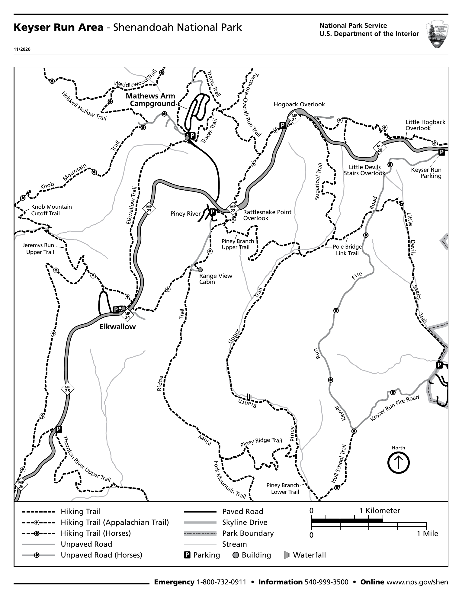
Open the full-size map ↗ · NPS · Keyser Run area map (PDF) ↗
Before heading out
Download the area map before arriving; reception can be unreliable. Allow time for the road crossing, climb, view, and return. My hiking time was not recorded.
Shenandoah is open year-round, but weather can close Skyline Drive. The standard private-vehicle pass is $30 for seven consecutive days, paid cashlessly. Check current fees and alerts before traveling.
NPS · Alerts and conditions ↗ · NPS · Entrance fees and passes ↗
Sources checked October 18, 2026. Check park notices before departure; these are planning notes, not a live trail-status report.
Photos from the hike
Photos coming soon
More moments from the trail are on the way.
A little more of the trail
Video coming soon
From the climb to the view, there’s more to share.