
Make room for the climb
Hawksbill reaches 4,051 feet above sea level, the highest point in Shenandoah National Park. The summit platform is the destination; which trail you choose changes the climb.
Lower Hawksbill is shorter and steeper. Upper Hawksbill gives you a longer approach with less elevation gain. Both options below return along the same trail to the same parking lot.
Difficulty · Lower is the steeper choice
NPS rates Lower Hawksbill Moderate, with about 75 minutes of hiking. Upper Hawksbill is rated Easiest, with about 90 minutes. Both climb to a rocky summit; build in additional time for the view and your own pace.
Start with the right parking lot
Option A / Lower Hawksbill · mile 45.5
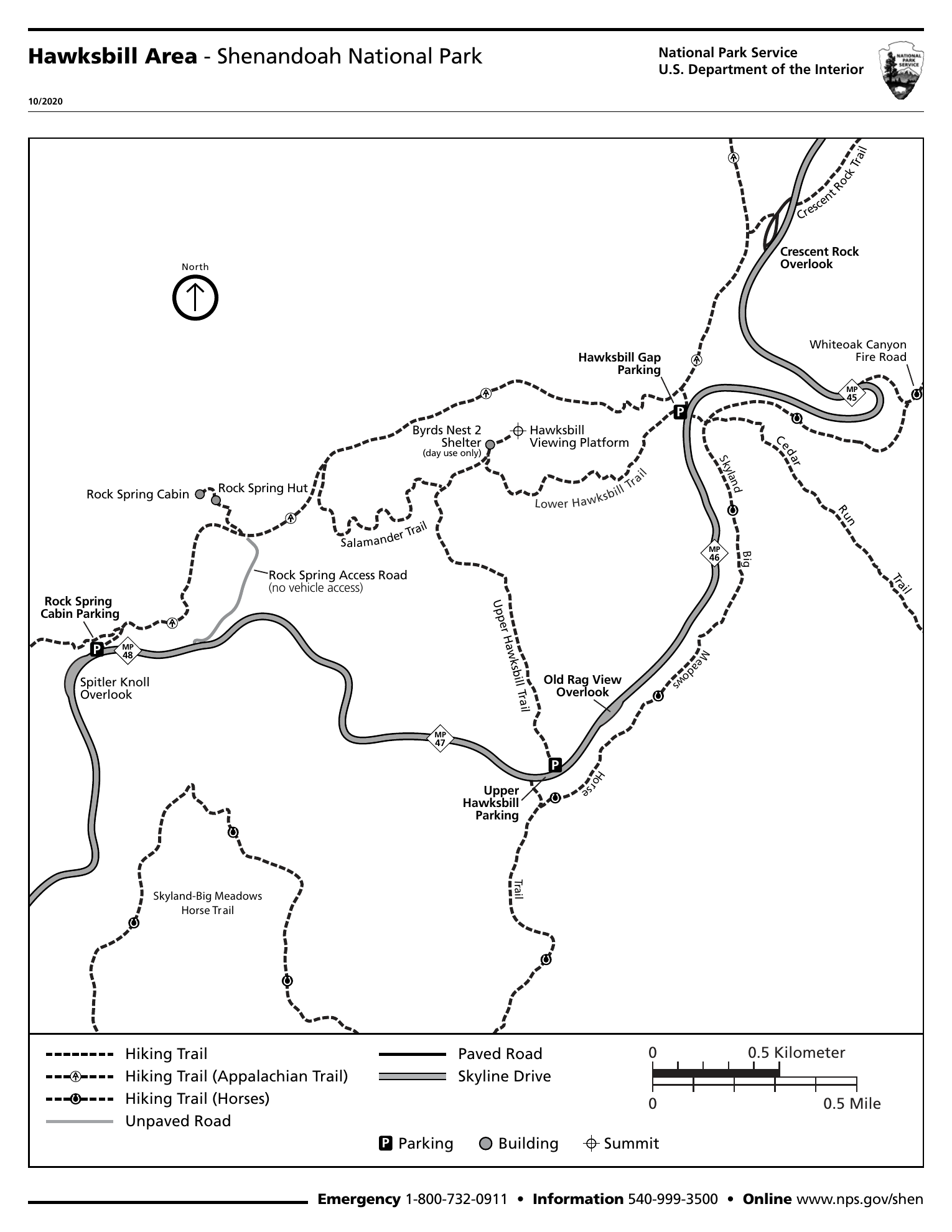
Start at Hawksbill Gap parking. Take Lower Hawksbill Trail uphill to Byrds Nest 2 Shelter, then continue on the short path to the viewing platform. This is the shorter, steeper, rockier approach. Retrace Lower Hawksbill to the same lot. Round trip: 1.7 miles; gain: 690 feet; NPS Moderate; about 75 minutes.
Option B / Upper Hawksbill · mile 46.5
Start at Upper Hawksbill parking. Follow Upper Hawksbill Trail to Byrds Nest 2 Shelter and continue to the viewing platform. Return on Upper Hawksbill to your starting lot. Round trip: 2.1 miles; gain: 520 feet; NPS Easiest; about 90 minutes.
At the top / Pause, then retrace
The platform is beyond the shelter. Enjoy the open outlook, then descend by the same trail you climbed. Switching Upper and Lower on the way down will put you at a different lot. The separate 2.9-mile Hawksbill loop is not either out-and-back route above.
Stay within open, signed areas. Some rock outcrops have limited closures to protect sensitive habitat. Pets must stay on a physical leash no longer than six feet.
NPS · Hawksbill Summit via Lower Hawksbill ↗ · NPS · Upper Hawksbill trailhead ↗ · NPS · Hawksbill area map (PDF) ↗ · NPS · Protecting rock outcrops ↗
More than a summit view
History of the trail and its surroundings
Geologic history / A volcanic beginning
Hawksbill’s cliffs are made from greenstone: ancient lava changed by later heat and pressure. NPS dates these lava flows to roughly 570 million years ago. Stacked flows help explain the park’s cliff-and-bench landscape. The summit is a remnant of events vastly older than the hiking trails and the park itself.
Human history / The mountains had neighbors
The landscape around Hawksbill and Skyland was not empty when the park was proposed. Nearby mountain communities farmed, worked, and traded. In the 1930s, Virginia assembled parkland from thousands of tracts through purchases and condemnation. NPS’s archaeological history describes at least 500 families displaced during the park’s creation. This is the regional history around the hike, not evidence of a settlement on the summit.
Human history / Recovering the fuller story
Later archaeological research in Nicholson, Corbin, and Weakley Hollows challenged the stereotypes used to portray mountain residents as isolated and backward. It documented varied homes, livelihoods, and connections with places such as Skyland. Reading that history alongside the summit view gives the landscape another dimension: a national park can protect a place while its creation also carries a human cost.
A map to take with you
Before heading out
Plan for both the uphill effort and the descent. Carry water, layers, and a saved map, and allow extra time at the summit. The shelter is marked for day use on the NPS map.
Shenandoah is open year-round, but weather can close Skyline Drive. The standard private-vehicle pass is $30 for seven consecutive days, paid cashlessly. Check current fees and alerts before traveling.
NPS · Alerts and conditions ↗ · NPS · Entrance fees and passes ↗
Sources checked October 18, 2026. Check park notices before departure; these are planning notes, not a live trail-status report.
Photos from the hike
Photos coming soon
More moments from the trail are on the way.
A little more of the trail
Video coming soon
From the climb to the view, there’s more to share.