My Bearfence route: the rock scramble
I took the rock scramble at Bearfence. That’s the route featured here: a short outing with exposed climbing and a 360-degree viewpoint.
The route details below follow the park’s published directions. I’ve also included the no-scramble viewpoint approach as an optional alternative for anyone who wants a different kind of outing.
Difficulty · NPS Moderate
The rock scramble involves exposed climbing and is unsuitable for hikers uncomfortable with heights. NPS advises against attempting it when wet or icy. The short mileage does not remove the need for careful footing and time for the climb.
The scramble, step by step
01 / Bearfence parking, mile 56.4
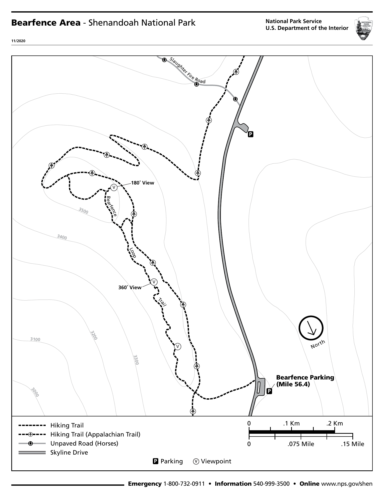
Start at the signed parking area on Skyline Drive. Cross carefully and climb the steps to the trail post. For the scramble, continue straight onto Bearfence Loop Trail.
02 / Scramble, view, and AT return
Follow the marked scramble to the 360-degree view. Beyond it, turn right onto the connector, then right onto the northbound AT. At the return junction, turn left toward parking. NPS lists 1.4 miles total, 311 feet of gain, and about 1 hour.
Optional alternative / No-scramble viewpoint
For this alternative, turn right onto the southbound AT at the initial post. Take the connector left, then turn right onto Bearfence Loop Trail to the 180-degree viewpoint. Retrace your steps: 1.1 miles round trip, 305 feet of gain, NPS Easiest, about 45 minutes. This is not the route I took.
Both options use a portion of Bearfence Loop Trail, where pets are prohibited. The rock scramble is unsuitable for hikers uncomfortable with heights. Stay with the blazes and keep off fragile vegetation.
NPS · Bearfence Rock Scramble ↗ · NPS · Bearfence area map (PDF) ↗
Who could enjoy these mountains?
History of the trail and its surroundings
Human history / Nearby Lewis Mountain
Bearfence is in the Central District, close to another place whose story deserves attention: Lewis Mountain, around Skyline Drive mile 58. In the park’s early years, Black visitors faced segregated facilities and exclusion from many accommodations. Lewis Mountain was developed for Black guests, with a campground, cabins, and dining facilities. This history belongs to the nearby developed area, not to an event documented on the Bearfence rocks.
NPS · Central District history ↗ · NPS · Segregation and desegregation ↗
Human history / Hospitality and change
NPS remembers campground manager Lloyd Tutt and his wife Mittie, whose cooking became well known. Lewis Mountain appeared in the Green Book, which helped Black travelers find places to eat and stay. Dinners and dances sometimes drew mixed crowds despite official segregation. Integrating the park took years of conflict between federal officials and the concessioner; NPS dates completed desegregation to 1950.
NPS · Central District history ↗ · NPS · Segregation and desegregation ↗
Trail history / Work behind a day outside
The broader park trail system also carries a New Deal legacy. From 1933 to 1942, CCC workers built trails, signs, overlooks, and other visitor facilities throughout Shenandoah. Their labor helped make mountain recreation accessible to more visitors, even while racial barriers limited who could use park services equally. The park-wide record does not identify the builder of each Bearfence trail segment.
A map to take with you
Before heading out
Allow more time than the NPS estimate for rests and photos. Carry water and a saved map. If the rocks are wet or icy, choose another outing rather than attempting the scramble.
Shenandoah is open year-round, but weather can close Skyline Drive. The standard private-vehicle pass is $30 for seven consecutive days, paid cashlessly. Check current fees and alerts before traveling.
NPS · Alerts and conditions ↗ · NPS · Entrance fees and passes ↗
Sources checked October 18, 2026. Check park notices before departure; these are planning notes, not a live trail-status report.
Photos from the hike
Photos coming soon
More moments from the trail are on the way.
A little more of the trail
Video coming soon
From the climb to the view, there’s more to share.