
Slow down for the rocks and the view
Blackrock’s boulder field opens toward the Shenandoah Valley and Massanutten Mountain. The park’s one-mile circuit combines time on the Appalachian Trail with a close look at a rocky slope that is still changing.
There is room here for more than a quick photograph. Notice the layers in the quartzite, follow the established trail, and give the view a few unhurried minutes.
Difficulty · NPS Easiest
This is a short hike with modest climbing, but the rocky setting still calls for attention to footing. NPS says the trail does not meet ADA accessibility guidelines. The circuit follows the established route around the slope; scrambling over the boulders is not required by these directions.
The one-mile circuit
01 / Blackrock parking · mile 84.4
Use the signed Blackrock Summit parking area in the South District. Follow the Appalachian Trail south from the lot.
02 / Turn toward the boulder field
At the trail post, turn right and continue to the rocks and viewpoint. This is the main payoff: the valley and Massanutten Mountain beyond.
03 / Around the slope
Continue south on the AT around the rocky slope. Stay with the established route and take care on uneven ground.
04 / Close the circuit
At the next junction, turn left onto the Blackrock Hut Road-Trayfoot Mountain Trail and follow it back to the parking lot. The full circuit is one mile with 175 feet of gain.
The route-specific NPS hike page and January 2025 map both identify the parking at mile 84.4. Follow the signed Blackrock Summit parking area. Pets are allowed on a physical leash no longer than six feet.
NPS · Blackrock Summit ↗ · NPS · Loft Mountain / Blackrock map (PDF) ↗
From ocean sand to mountain stories
History of the trail and its surroundings
Geologic history / An ancient shoreline
Blackrock’s quartzite began as sand associated with the ancient Iapetus Ocean more than 500 million years ago. Mountain-building later compressed and heated the deposits, fusing quartz grains into resistant rock. Weathering broke a former cliff into the talus slope visible today. Water, ice, and roots continue to loosen pieces and move them downhill.
Human history / Long before the park
The wider Blackrock region preserves evidence of Indigenous life thousands of years before modern tourism. Virginia’s Department of Historic Resources dates materials from the Blackrock Springs Archaeological Site to about 5500-1000 BCE. Researchers studied more than 3,000 artifacts. That separate archaeological site is not the summit circuit and is not a stop on this hike.
Human history / A different kind of getaway
Elsewhere in the South District, Black Rock Springs attracted resort visitors by the 1830s. NPS notes a newspaper reference from 1835, while the exact founding date remains uncertain. A 1909 fire destroyed the resort; a surviving school building later served as the hotel until the park era. The hotel site is separate from Blackrock Summit, but its story shows that people sought mountain escapes here long before Skyline Drive.
A map to take with you
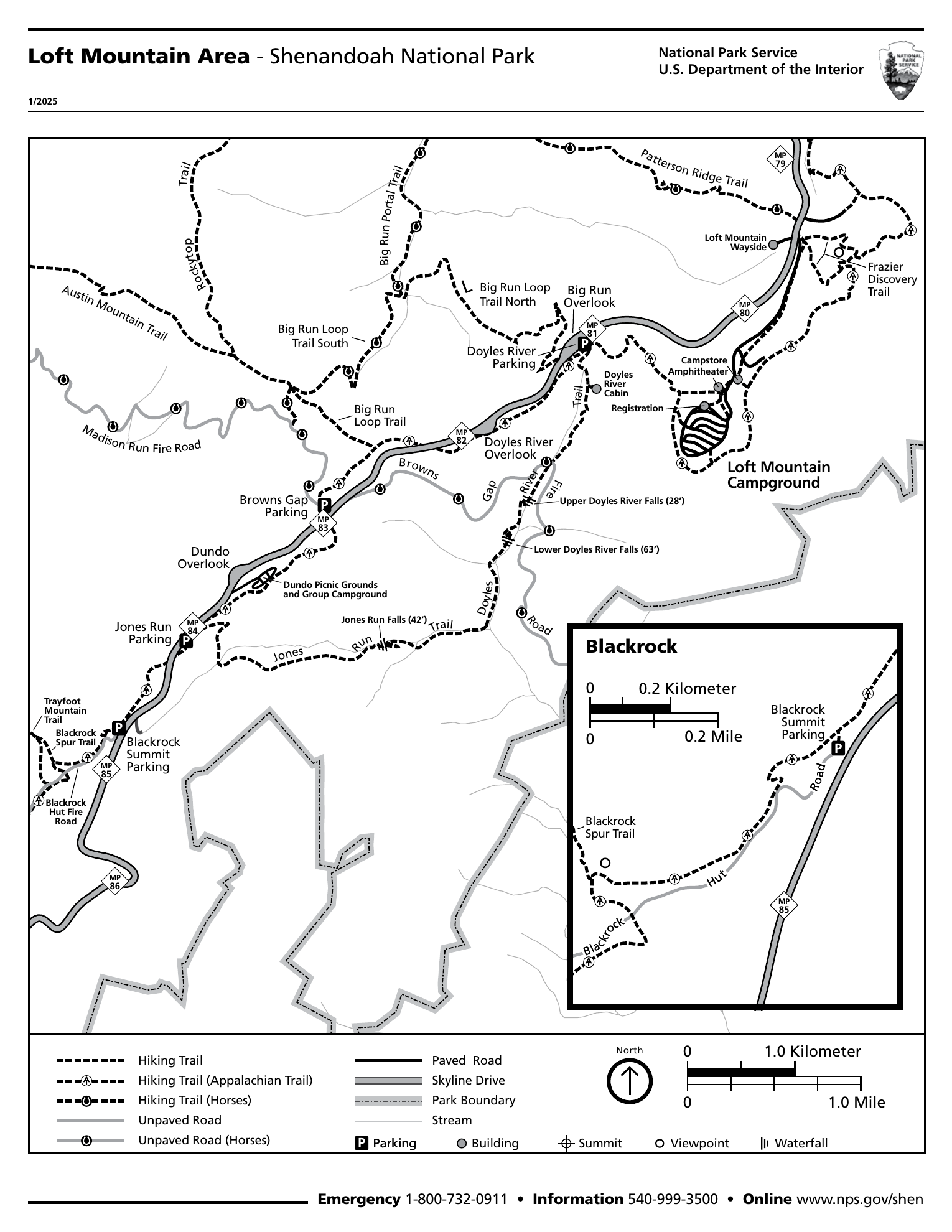
Open the full-size map ↗ · NPS · Loft Mountain / Blackrock map (PDF) ↗
Before heading out
NPS estimates 45 minutes of hiking; pauses add time. Carry water, a light, layers, and the saved map. Keep feet and gear off vegetation around the boulders.
Shenandoah is open year-round, but weather can close Skyline Drive. The standard private-vehicle pass is $30 for seven consecutive days, paid cashlessly. Check current fees and alerts before traveling.
NPS · Alerts and conditions ↗ · NPS · Entrance fees and passes ↗
Sources checked October 18, 2026. Check park notices before departure; these are planning notes, not a live trail-status report.
Photos from the hike
Photos coming soon
More moments from the trail are on the way.
A little more of the trail
Video coming soon
From the climb to the view, there’s more to share.